4 things to know about the weather:
- Weather alert this afternoon
- Strong/severe storms 3 to 9 p.m.
- Sunday drier than Saturday
- Cooler next week
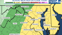
The D.C. area will have a risk for strong to severe thunderstorms as a cold front moves in from Pennsylvania on Thursday afternoon.
All is quiet before noontime, but if you’re going to be out later into the afternoon and evening, you should have your umbrella with you, and you should be aware that storms are likely to slow the evening commute.
The main severe weather threats will be damaging wind gusts nearing 60 mph and the risk of localized flash flooding under some of the slower-moving storms.
On average, those who get rain on Thursday will get about a half-inch. Totals well over 1 inch are likely with the strongest storms.
If you or your kids will be at the local pools on this hot afternoon, remember to head for safe shelter at the first rumble of thunder. Go here to track storm watches and warnings.
Weather radar
Download the NBC Washington app on iOS and Android to check the weather radar on the go.
Highs this afternoon will be about 90° before the storm clouds develop. Any storms that last into the evening will be over by midnight, and the remainder of the overnight will be mild and muggy.
Friday’s rain chances have been lowered. Most of our Friday will be cooler and drier than Thursday, with highs only reaching the lower-80s. There’s still a chance for scattered storms later Friday afternoon and evening, but the intensity and coverage area will be far less than Thursday.
Weather for this weekend – including for DC’s Freedom 250 Grand Prix on Sunday
A wave of low pressure will develop along that cold front and move back into our area on Saturday. This guarantees high rain chances on Saturday, but the entire day won’t be a loss. The most likely times to be dry will come from mid-morning into early afternoon.
That said, no one time can be promised to stay dry, so outdoor plans will need a contingency. Highs on Saturday will be in the lower 80s, with very high humidity levels.
Another cold front will arrive on Sunday. Ahead of the front, we should get enough sunshine to boost temperatures into the mid-80s. As the front passes, there will be thunderstorms scattered across the area in the 3 to 7 p.m. time frame.
Rain will be less impactful on Sunday, but there will be a risk of rain during the Freedom 200 Grand Prix in D.C. Cooler, quieter and less humid weather arrives for the first half of next week.
QuickCast
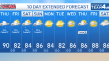
TODAY:
Increasing clouds, humidity
Rain, thunderstorms after 3 p.m.
Some severe storms likely
Wind: variable 5-10 mph
Chance of rain: 80%
HIGHS: 86° to 92°
TONIGHT:
Evening storminess
Drying after midnight
Muggy and mild
Wind: north 5 mph
Chance of rain: 30%
LOWS: 66° to 72°
FRIDAY:
Mostly cloudy, very humid
Mainly dry before 4 p.m.
Scattered evening storms
Wind: northeast 5-10 mph
Chance of rain: 20%
HIGHS: 78° to 83°
SATURDAY:
Cloudy and humid
Periods of rain likely
Late afternoon thunderstorms
Wind: southeast 5-10 mph
Chance of rain: 70%
HIGHS: 78° to 84°
SUNDAY:
Warmer, more sunshine
Mainly dry before 2pm
Scattered storms 3-8 pm
Wind: northwest 5-10 mph
Chance of rain: 25%
HIGHS: 80° to 85°
Sunrise: 6:26; sunset: 7:56
Average high: 88°; average low: 71°