Strong storms are moving through the Washington, D.C., region on Saturday as the entire region remains under an air quality alert.
Montgomery and Prince George’s counties were under a tornado watch and Anne Arundel, Calvert, Frederick and Howard counties are also under a tornado watch, which expired at 9 p.m. Go here for all weather alerts.
A tornado warning also expired for parts of Montgomery and Frederick counties. A tornado warning means a threat is imminent, and anyone in an affected area should immediately take cover.
The D.C. area was under a severe thunderstorm watch, but it expired at 9 p.m.
Weather radar
Download the NBC Washington app on iOS and Android to check the weather radar on the go.
Tracking severe storms
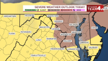
Locally strong to severe storms will be capable of producing very heavy rain and the risk of urban and flash flooding. A flood watch was in effect until 8 p.m. but has since expired.
Storms will linger into late Saturday night before tapering off around sunrise Sunday morning. Sunday afternoon and Monday will turn out to be quite nice, followed by a humid and stormy Tuesday.
Storms have dumped heavy rain onto Montgomery County, leading to power outages and even a Gaithersburg house fire caused by a lightning strike. News4’s Dominique Moody reports.
Air quality alert
Code red, unhealthy air quality persists Saturday in much of the region. Code red means everyone should limit time spent outdoors, especially if they’re doing strenuous activities.
Overall, a code orange air quality alert is in effect, which means conditions are unhealthy for sensitive groups. Air quality can shift from one neighborhood to the next and throughout the day.
Southwest winds will increase, and the change in wind direction will improve the air quality but bring high humidity along with it. A heat advisory has been issued.
Highs in the low 90s and a heat index topping 100° are on tap before storms finally arrive.
QuickCast
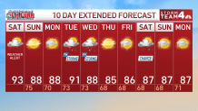
TODAY
WEATHER ALERT | Smoky | Hot & Humid | 40% Chance PM Storms
HIGHS: Mid 90s
TONIGHT
Partly Cloudy | Storms Ending
Temps: 70s Area-Wide
SUNDAY
Partly Sunny
HIGHS: Upper 80s
MONDAY
Partly Sunny
HIGHS: Upper 80s
TUESDAY
Partly Sunny | Scattered Showers & Storms (40% Chance)
HIGHS: Lower 90s
SUNSET: 8:31
Averages: 89/73F