4 things to know about the weather:
- Heat index values could reach or exceed 100°
- Scattered storms Friday afternoon
- Daily storm chances will continue through Saturday
- A drier stretch develops Sunday into Monday
Summer heat remains across the D.C. metro area and surrounding suburbs.
Hot and humid conditions continue Friday with highs near 90° to 93°. Heat index values could reach or exceed 100°.
Scattered afternoon and evening thunderstorms may produce heavy rain and gusty winds. A few of these storms could be severe. Storm chances will be highest from 2 to 8 p.m. Scattered storms will gradually diminish Friday night.
Sunday will be the nicer day of the weekend
Saturday will be hot and humid again with storm chances. A few storms may bring locally heavy rain. It won’t be a washout, but keep an eye on the sky, especially between 3 and 9 p.m.
Sunday will be the better day of the weekend for outdoor plans, with a lower risk for storms. It will still be humid, but you can plan for a generally pleasant summer day.
The D.C. area will remain hot next week. Rain chances will increase Wednesday.
Weather radar
Download the NBC Washington app on iOS and Android to check the weather radar on the go.
10-day forecast
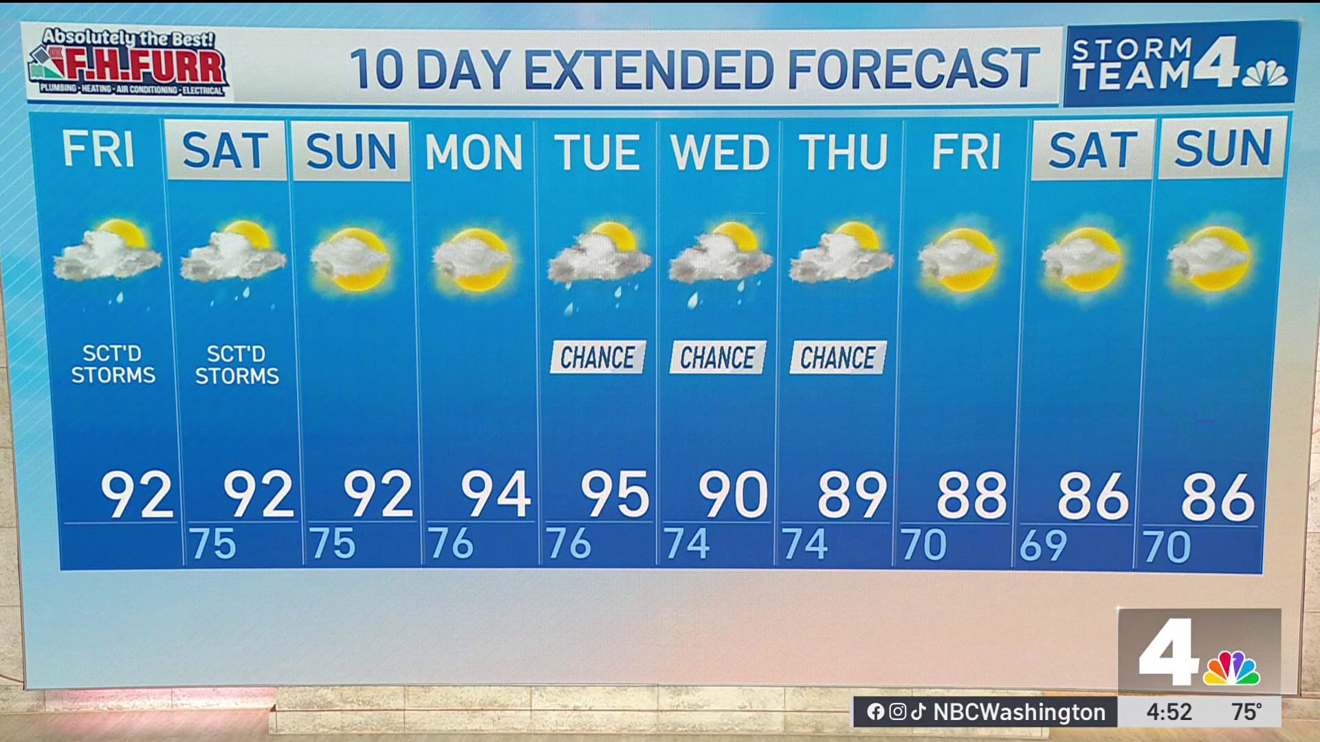
QuickCast
Friday
Partly sunny, hot and humid
Scattered afternoon and evening thunderstorms; heavy rain & gusty winds possible
Highs: 88°-93°
Heat index about 100°-103°
Storm coverage increases late afternoon
Best chance for storms: 2-8 p.m.
Wind: SW 5-10 mph
Friday Night
Scattered thunderstorms gradually diminish
Partly cloudy and muggy
Warm overnight conditions continue
Lows: 72°-76°
Saturday
Mostly sunny early, then partly sunny
Hot and humid
Scattered afternoon and evening thunderstorms; locally heavy rainfall possible
Not a washout, but keep an eye on the sky
Best chance for storms: 3-9 p.m.
Highs: 89°-93°
Wind: SW 5-10 mph
Saturday Night
A few early evening storms ending
Partly cloudy, warm, and humid
Lows: 73°-76°
Sunday
Mostly sunny and very warm; still humid but generally pleasant
Lower storm risk than previous days
Great day for outdoor activities
Highs: 89°-93°
Wind: NW becoming variable 5-10 mph
Sunday Night
Partly cloudy and muggy
Quiet weather expected
Lows: 73°-76°
Monday
Sunny, hot and humid; dry in most spots
Heat builds slightly during the afternoon
Highs: 92°-95°
Heat index near 100°
Wind: W to NW 5-10 mph
Monday Night
Partly cloudy and warm
Muggy conditions persist
Lows: 74°-77°
Tuesday
Mostly sunny, very hot and humid
A slight chance of a late-day thunderstorm
Highs: 92°-96°
Heat index may reach 100°-104°
Best chance for storms: 4-9 p.m.
Wind: W 5-10 mph
Tuesday Night
Partly to mostly cloudy
A few scattered evening thunderstorms possible
Lows: 74°-77°
Wednesday
Partly sunny and humid
Greater coverage of showers and thunderstorms expected
Some storms may bring heavy downpours
Slightly lower temperatures due to increased cloud cover; highs: 88°-92°
Best chance for storms: afternoon through evening
Wind: Variable 5-10 mph
Wednesday Night
Partly cloudy with lingering showers ending
Warm and humid
Lows: 72°-75°