4 things to know about the weather:
- Rain has moved out
- Chilly, blustery Saturday
- Warmer Sunday
- Dry Saturday through Wednesday
Storm Team4 is tracking cooler air moving in overnight.
A cold front, which will bring an end to all the rain, won’t come through until overnight tonight.
Cooler fall weather this weekend.
Cooler, drier air will arrive overnight, helping to break up the clouds and set the stage for a mostly sunny weekend. Temperatures will be about 20° lower in the mid-40s on Saturday morning. Northwest winds and highs in the mid-to-upper 50s will have Saturday afternoon feeling very much like November.
It will be a chilly start, but there will be less wind and plenty of sunshine on Sunday, with highs getting back into the low 60s. The dry pattern will last from Saturday all the way through Wednesday, which is Veteran’s Day, as temperatures move back into the mid 60S.
Download the NBC Washington app on iOS and Android to check the weather radar on the go.
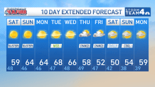
QuickCast
FRIDAY NIGHT:
Cloudy evening
Some overnight clearing
Breezy, colder
Wind: northwest 5-15 mph
Chance of rain: <20%
LOWS: 58° to 66°
SATURDAY:
Breezy and much cooler
Some clouds early
Mostly sunny by noontime
Wind: northwest 15-25 mph
Chance of rain: 0%
HIGHS: 55° to 60°
SUNDAY:
Mostly sunny
A COLD start
Breezy at times
Wind: northwest 10-20 mph
Chance of rain: 0%
HIGHS: 58° to 62°
MONDAY:
Mostly sunny
Blustery
Very low humidity
Wind: northwest 15-30 mph
Chance of rain: 0%
HIGHS: 60° to 65°
Sunrise: 6:41 Sunset: 5:02
Average High: 62° Average Low: 45° See less
Stay with Storm Team4 for the latest forecast. Download the NBC Washington app on iOS and Android to get severe weather alerts on your phone.